Part of the Western NY Hub
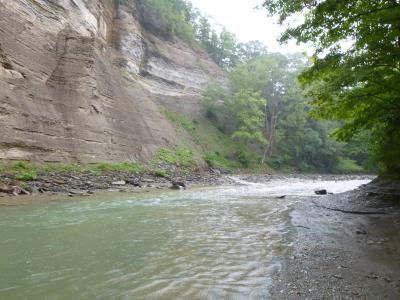
Carved by the relentless power of Cattaraugus Creek, the 3,000-acre Zoar Valley Multiple Use Area is a rugged, 11-mile canyon in Western New York renowned for its towering 400-foot cliffs, hidden waterfalls, and old-growth forests.
Zoar Valley Multiple Use Area: What to Know
If you get hurt here, rescue takes hours. Zoar Valley Multiple Use Area is a raw, wild landscape with zero safety buffers. Spanning over 3,000 remote acres, Zoar Valley Multiple Use Area is NOT a state park. It is a rugged natural landscape with no rangers, zero cell service, and absolutely no trash cans.
Essential Rules & Visitor Info
- Not a State Park: There are no park rangers, paved trails, or public restrooms.
- Zero Cell Service: Do not count on your phone for maps, calls, or emergencies.
- No Amenities: There are no trash cans; you must carry out all garbage.
DEC Regulations
- Carry In / Carry Out: Every piece of trash you bring must leave with you.
- No Lifeguards: Swift currents, hidden drop-offs, and undertows make swimming highly dangerous. Swimming and interacting with swift water carry extreme, life-threatening hazards.
- Restricted Parking: You may only park at the Valentine Flats Road lot or the Forty Road lot. Illegal parking results in towing.
- No Glass or Alcohol: Possession of glass containers and alcoholic beverages is strictly prohibited.
Safety & Access
- The gorge features 100 to 500-foot cliffs with slippery, loose rocks and swift water. You should always stay at least 15 feet back from cliff edges and only access Cattaraugus Creek via the Valentine Flats Trail or Forty Road parking areas.
The Terrain
- Massive Scale: The area spans over 3,000 acres of dense forest and deep gorges.
- Extremely Remote: Help is far away, and the rugged terrain slows down emergency teams.
- Sheer Cliffs: Cliff edges are unstable and crumble easily; stay far back from the rims
Zoar Valley Hiking Trails & Waterfalls
- Valentine Flats Trail:
- 1.5 miles. Easy difficulty. Leads directly to the Cattaraugus Creek beach. Ideal choice for families. Note that the parking lot fills up completely by 10:00 AM on weekends.
- Holcomb Pond:
- Short loop trail. Active beaver colony present. Experiences significantly less crowding than other paths.
- Forty Road:
- Features a very steep descent down to the creek bed. Serves as the connector route to Deer Lick. Completely impassable during periods of high water.
- Deer Lick Falls:
- Showcases a stunning 30-foot waterfall. Requires a 2-mile hike starting from Forty Road. Terrain contains highly slippery rocks.
- Safety Alert:
- Trail conditions alter rapidly following major storms. Always review official DEC alerts prior to departure.
- For advisories, check NYS DEC Alerts.
Zoar Valley Swimming Holes & Safety
Visiting Zoar Valley offers pristine swimming, but Cattaraugus Creek is notorious for deadly flash floods, with water levels surging over 6 feet in 30 minutes following storms. There are strict rules and serious hazards, including sharp, shallow rocks, deep drops, and swift currents.
Dangers & Safe Zones
- Flash Floods: Cattaraugus Creek is highly susceptible to rapid, deadly rises in water levels. The water can rise over 6 feet in just 30 minutes following storms 20 miles upstream. There have been more than 15 drownings since 1990.
- Safest Spot: The Valentine Flats beach area is the safest entry point, where the water is typically ankle-deep during the summer. Even here, you must actively monitor the water level.
Crucial Crossing Rules
- Never cross the creek if any of the following conditions exist:
- The water is above your knees
- The current is moving fast and is brown or muddy (a sign of runoff or upstream storms)
- There are storms in the forecast
Rules & Regulations
- No glass bottles or alcohol are permitted
- No lifeguards are on duty at any time
- No diving is allowed due to hidden shallow rocks and underwater debris
Essential Safety Tips
- Safe gorge and creek access is only from authorized entry points like the Valentine Flats Trail and Forty Road parking lot.
- There are no safe, authorized trails on the Erie County side.
- Wear sturdy, water-resistant hiking boots or water shoes due to extremely slippery rocks and shale.
- Check the latest warnings through the National Weather Service before you head out.
- Review all official alerts and updates on the NYSDEC Zoar Valley Multiple Use Area page.
Camping Near Zoar Valley
Primitive Camping (Free)
- Free, primitive camping is allowed on a first-come, first-served basis at designated sites along Valentine Flats Road and Forty Road.
- No Amenities: There is no running water, no electricity, and no toilet facilities.
- Strict Rules: You must pack out all of your trash (Carry In / Carry Out).
- Safety Alert: If you get hurt here, emergency rescue takes hours. Zoar Valley is a remote, 3,000+ acre area with no park rangers on-site and virtually zero cell phone service.
- Gorge Hazards: The property contains steep cliffs, loose rocks, and fast water. For your safety, stay completely on the marked trails and remain at least 15 feet away from all cliff edges.
- Restrictions: Open campfires, alcohol, and glass containers are strictly prohibited.
Nearby Developed Camping (Paid)
If you prefer amenities like running water, flush toilets, and electricity, several paid options are located a short drive from the valley:
- Chestnut Ridge Park, 6121 Chestnut Ridge Rd, Orchard Park, NY 14127: Located in Orchard Park, this county park offers expansive hiking trails, a disc golf course, and close proximity to the famous Eternal Flame Falls.
- Website: Chestnut Ridge Park
- Evangola State Park 10191 Old Lake Shore Rd, Irving, NY 14081: Situated right on the shores of Lake Erie, this park features 80 well-spaced campsites, flush toilets, hot showers, and a natural sand beach.
- Website: Evangola State Park
- Hogarosa Campground at 11847 Summit Ln, Springville, NY 14141: A popular local private campground that offers tent and RV sites alongside fishing ponds and live music events.
- Phone: (716) 381-7355
Directions: Zoar Valley from Buffalo & Springville
🗺️ Overview Map from Buffalo to Zoar Valley Valentine Flats
📍 Open Full Multi-Stop Route on Google Maps
🗺️ Overview Map from Springville to Zoar Valley Valentine Flats
📍 Open Full Multi-Stop Route on Google Maps
🗺️ Overview Map from Near Me to Zoar Valley Valentine Flats
📍 Open Full Multi-Stop Route on Google Maps
Zoar Valley vs Letchworth: Which to Hike
| Zoar Valley | Letchworth | |
| Fees | Free | $10 vehicle |
| Crowds | Empty weekdays | Packed weekends |
| Safety | No rangers, no cell | Rangers, facilities |
| Trails | Unmarked, rugged | Paved, signed |
| Best for | Experienced hikers | Families, beginners |