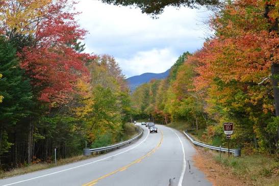
Part of the New England Hub
The Kancamagus Highway, NH Route 112, is a 34.5-mile scenic byway through White Mountain National Forest. Famous for fall foliage, it connects Lincoln to Conway with no gas stations or services. This guide covers Sabbaday Falls, Rocky Gorge, Sugar Hill Overlook, parking, and peak color timing.
Kancamagus Highway Map & Driving Directions
The Kancamagus Highway (NH Route 112) is a 34.5-mile scenic byway connecting Lincoln to Conway, New Hampshire. The drive takes about 1 hour without stopping, but requires preparation since there are no gas stations, no restaurants, and no cell service along the route. Lincoln is the west entrance, Conway is the east.Directional Guide
- East to West (Conway to Lincoln): Starting on the east side, you steadily climb the hairpin turns to the Kancamagus Pass (elevation 2,855 ft). Many travelers prefer this direction if they want to get the steep climbing out of the way first.
- West to East (Lincoln to Conway): Starting in Lincoln, you will parallel the Pemigewasset River before ascending toward the pass, followed by a long, gentle descent alongside the Swift River. This direction is often preferred to save the popular waterfalls for the second half of the trip.
Essential Planning Tips
- Fill up Beforehand: Because there is no gas or food on the highway, fill your tank and pack meals or snacks before you enter.
- Offline Navigation: Download your maps offline before your trip, as cell service drops completely.
- Parking Pass: Parking at any of the scenic overlooks or trailheads requires a White Mountain National Forest Recreation Pass. A daily pass costs $5 and can be purchased at self-service kiosks along the route or at the ranger stations in either town. Lots full by 9am peak weekends.
Must-See Stops
- Lower Falls: A scenic Lower Falls area to view natural swimming holes and relax by the river.
- Sabbaday Falls: A short, accessible walk to a beautiful, multi-tiered waterfall.
- Rocky Gorge Scenic Area: A breathtaking Rocky Gorge Scenic Area featuring waterfalls and walking trails around Falls Pond.
Best Kancamagus Highway Stops & Overlooks
The following sequential guide lists the best stops and overlooks along the highway from west to east (Lincoln to Conway). Remember, there is no gas or food on the highway, fill your tank and pack meals or snacks before you enter. Some lots full by 9am peak weekends.
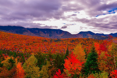
Hancock Overlook
Location: Kancamagus Hwy, Lincoln, NH 03251
Mile marker: ~10.5 miles east of Lincoln
Parking: Medium paved lot right at the famous hairpin loop. It fills up fast during peak autumn weekends.
Hike Distance: 0 miles for the scenic vista itself. The strenuous Hancock Notch hiking trail begins directly from this lot.
Photo Tip: Capture the sweeping westward views of the massive Osceola Mountain Range. If visiting during peak fall foliage, position yourself to capture the dramatic U-bend curve of the road below.
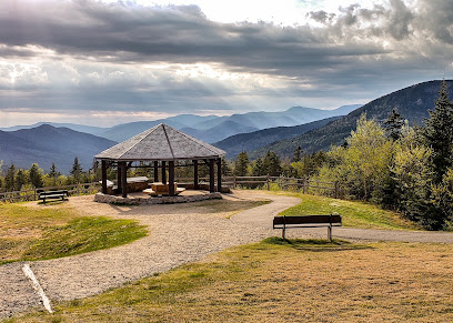
Pemigewasset Overlook
Location: Kancamagus Hwy, Albany, NH 03818
Mile marker: ~12.2 miles east of Lincoln
Parking: Large paved loop lot that offers easier entry and exit than Hancock Overlook.
Hike Distance: 0 miles. A wooden boardwalk, benches, and a large covered gazebo sit right at the parking edge.
Photo Tip: Facing directly west/northwest, this is arguably the premier spot on the entire highway for sunset landscape photography. Use the rustic wooden frames of the gazebo to beautifully anchor your mountain backdrop shots.
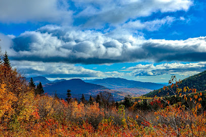
C.L. Graham Wangan Ground Overlook
Location: Kancamagus Hwy, Bartlett, NH 03812
Mile marker: ~13.5 miles east of Lincoln (just past the Kancamagus Pass summit)
Parking: Expansive paved parking loop capable of handling larger vehicles and RVs.
Hike Distance: 0 miles. Informative panels outlining local Native American history sit directly adjacent to the tarmac.
Photo Tip: Situated at nearly 3,000 feet of elevation, this spot provides unmatched morning frames of the Swift River Watershed. Arrive at dawn on crisp autumn days to shoot moody, low-lying valley fog catching the early morning sunlight.
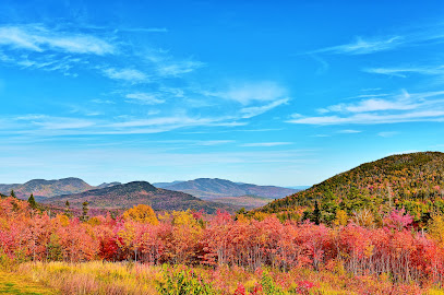
Sugar Hill Overlook
Location: Kancamagus Hwy, Albany, NH 03818
Mile marker: ~15.2 miles east of Lincoln
Parking: Paved pull-off lot with an on-site wooden shelter and park benches.
Hike Distance: 0 miles. The panoramic mountain views are entirely roadside.
Photo Tip: This east-facing vista looks directly out over Mt. Tremont and Bear Mountain. It is best shot during the mid-to-late afternoon when the sun is positioned behind you, casting rich, direct light on the rolling hillsides.
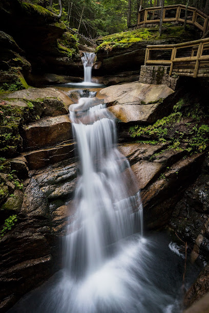
Sabbaday Falls
Location: Kancamagus Hwy, Waterville Valley, NH 03259
Mile marker: ~16.5 miles east of Lincoln (roughly halfway across the highway)
Parking: Large paved loop lot with public restrooms and picnic tables.
Hike Distance: 0.6 to 0.7 miles round-trip. It is a very flat, evenly graded crushed gravel path.
Photo Tip: A wooden boardwalk and a steep stone staircase follow the edge of the falls. Stand on the wooden footbridge right above the upper potholes to shoot down into the narrow, pristine glacial flume.
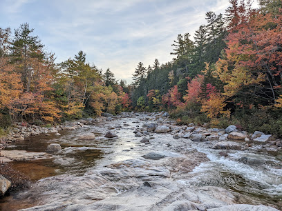
Rocky Gorge Scenic Area
Location: Kancamagus Hwy, Albany, NH 03818
Mile marker: ~26.5 miles east of Lincoln (approx. 8 miles west of Conway)
Parking: Large paved parking lot equipped with vault restrooms and a self-pay pass station.
Hike Distance: 0.1 miles to the gorge bridge. From there, you can extend your walk along the flat 1.1-mile Lovequist Loop around Falls Pond.
Photo Tip: Stand directly in the center of the wooden pedestrian footbridge. Use a polarising filter to cut through surface glare and capture the powerful, churning emerald waters of the Swift River rushing over smooth granite channels.
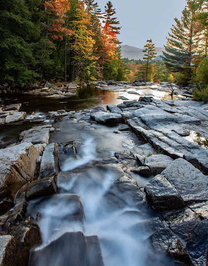
Lower Falls
Location: Kancamagus Hwy, Albany, NH 03818
Mile marker: ~28.5 miles east of Lincoln (approx. 6 miles west of Conway)
Parking: Very large, wide paved parking loop featuring an expansive covered picnic pavilion and restrooms.
Hike Distance: 0 miles. The river's granite ledges sit immediately at the edge of the parking lot tarmac.
Photo Tip: Walk out onto the vast, dry granite boulders tracking the edge of the rapids. Crouch down low to use the rushing river cascades as a dynamic foreground element, framing the mixed birch and maple trees on the opposite bank.
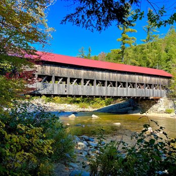
Albany Covered Bridge
Location: Kancamagus Hwy, Albany, NH 03818
Mile marker: ~32.0 miles east of Lincoln (approx. 2.5 miles west of Conway)
Parking: Medium-sized paved parking lot on the north side of the Swift River.
Hike Distance: 0.1 miles to walk inside the bridge structure. It connects directly to the 3.4-mile Boulder Loop Trail if you are looking for a longer hike.
Photo Tip: Walk downstream along the dirt paths tracking the riverbank. Frame your shot from the water's edge to capture the historical timber bridge reflecting off the Swift River, perfectly flanked by overhanging fall foliage.
🗺️ Overview Map of all 8 Kancamagus Highway Stops & Overlooks 📍 Open Full Multi-Stop Route on Google Maps
Sabbaday Falls & Rocky Gorge: Top Kancamagus Hikes
Sabbaday Falls and Rocky Gorge are two of the most popular, accessible, and scenic stops along the Kancamagus Highway (NH Route 112). Both are family-friendly, require minimal hiking, and feature stunning White Mountains river scenery.Sabbaday Falls
- The Hike: An easy 0.7-mile out-and-back trail with a minimal elevation gain (~98 ft). The packed gravel and dirt path leads along a shaded brook.
- The Sights: Features a stunning 35-foot, 3-tier cascade that cuts through a narrow rock flume and feeds into a vibrant green pool. A mini loop trail with wooden boardwalks and stairs lets you view the plunging drops from both the bottom and upper stretches.
- Details: Swimming is strictly prohibited here. Check out trail maps and visitor tips on AllTrails.
Rocky Gorge
- The Hike: Extremely short and easy, this is practically a roadside walk of less than 0.3 miles.
- The Sights: Located near Mile 26.4 of the Kancamagus, this site features a roaring, 15-foot waterfall plunge where the rushing Swift River is squeezed through a narrow, jagged rock gorge. A scenic footbridge crosses the river just below the gorge, providing fantastic photo opportunities.
- Details: Like Sabbaday, swimming is prohibited here due to strong currents and hazards. You can find more traveler perspectives on Tripadvisor.
Planning Your TripParking Pass:
- Both locations are part of the White Mountain National Forest and require a $5 per-car day-use fee (or display an America the Beautiful/Federal Recreation Pass).
- Getting There: The parking lot for Sabbaday Falls is located roughly 19.9 miles west of Conway, while Rocky Gorge is about 6.5 miles further west. Lots full by 9am peak weekends.
Kancamagus Highway Fall Foliage: Peak Dates & Forecast
The 2026 Forecast & Timing
- Peak Timing (Oct 1–15): The 34.5-mile scenic highway connecting Lincoln and Conway generally hits its technicolor crescendo during this window.
- The 2026 Outlook: Projections point to a vibrant 2026 autumn. Favorable precipitation earlier in the year ensures a robust, healthy leaf canopy that sets up excellent, long-lasting displays.
- Elevation Matters: The Kancamagus crosses the White Mountains, rising to an elevation of nearly 2,860 feet at Kancamagus Pass. Because temperature drops with elevation, the highest peaks change first (late September), while the lower elevations near Lincoln (West) and Conway (East) lag by a few days.
Why the "Kanc" Delivers the Best Foliage
- Tree Varieties: The White Mountain National Forest is heavily dominated by sugar maples (providing brilliant reds and oranges), birches (creating glowing yellows), and beeches (offering deep bronze tones).
- Unspoiled Views: Unlike many foliage drives, this route cuts directly through a protected national forest. You won't find billboards, power lines, or commercial buildings obstructing the tree line, which gives it a deeply immersive, wild New England feel.
- No Services on the Kanc: The 34.5-mile stretch has no gas stations, restaurants, or convenience stores. Fill up your tank and pack snacks in Lincoln or Conway before entering.
- Popular Stops: Give yourself 2–3 hours to drive it so you can pull over at scenic overlooks and easily hike to spots like Sabbaday Falls.
Here is how historical averages and the 2025 season unfolded:
- 10-Year Average: Peak viewing consistently arrives in the White Mountains between late September and the second week of October (usually wrapping up just after Columbus Day weekend).
- 2025 Data: The foliage season arrived slightly earlier than usual. High colors emerged by late September. By the first week of October, many areas along the western side of the highway had already peaked or moved into the "past peak" stage.
Kancamagus Highway Parking, Fees & Safety
A $5/day White Mountain National Forest pass is required at trailheads and major parking lots along the Kancamagus Highway (NH Route 112). You can pay with cash or credit at self-serve kiosks, or display an America the Beautiful (Interagency) pass. Some lots full by 9am peak weekends.
Key safety and logistical considerations include:- No Cell Service: Cellular reception drops to zero shortly after entering the highway. Download all maps, directions, and guides offline beforehand.
- No Gas: There are no gas stations along the 34.5-mile highway. Fill up in Lincoln (west) or Conway (east) before starting the drive.
- Wildlife: Black bears and moose are common. Store all food and scented items in bear-proof containers or your car to avoid attracting wildlife.
- Weather: Weather conditions in the White Mountains change rapidly. Always pack layers and rain gear, even on a sunny day.
Kancamagus Highway Itinerary: Lincoln to Conway
Morning: Lincoln to the Scenic Overlooks
- Start in Lincoln, NH, heading east onto Route 112.
- Stop 1: Lincoln Woods Trailhead (Mile 4): A massive trailhead featuring a suspension bridge that crosses the East Branch of the Pemigewasset River. Great for a brisk morning walk.
- Stop 2: Hancock Overlook (Mile 11): Offers panoramic views of the White Mountains and Mount Huntington.
- Stop 3: Pemigewasset Overlook (Mile 14): Located near the crest of the highway, it provides sweeping views of the valley and is a prime spot for foliage.
- Stop 4: C.L. Graham Wangan Overlook (Mile 16): A high-elevation vista that looks out across the vast expanse of the White Mountain National Forest.
Midday: Sabbaday Falls
- Drive about 5 miles east from the C.L. Graham Overlook to reach Sabbaday Falls (Mile 21).
- The Hike: A family-friendly, well-maintained 0.3-mile trail leads to a stunning 35-foot, three-tiered waterfall.
- Picnic: There are shaded picnic areas near the parking lot. Bring your own lunch, as there are no restaurants on the highway.
Afternoon: Rocky Gorge & Albany Bridge
- Continue east toward Conway.
- Stop 5: Rocky Gorge Scenic Area (Mile 27): Just a short paved walk from the parking lot brings you to a roaring, glacier-carved gorge. Cross the wooden footbridge over the rapids, then take the short 0.1-mile trail up to the tranquil Falls Pond.
- Stop 6: Albany Covered Bridge (Mile 30): Just a couple of miles east of Rocky Gorge, this historic 1858 paddleford-truss covered bridge spans the Swift River. You can walk across and view the river, or take pictures from the riverbank.
Evening: End in Conway
- From the Albany Covered Bridge, it is an easy 6-mile drive east to reach Conway and North Conway, NH, where you will find abundant lodging, dining, and shops to end your day.
Where to Stay: Lincoln NH & North Conway
Lincoln and North Conway serve as the perfect bookends for a White Mountains trip, each anchoring one side of the 34.5-mile Kancamagus Highway (Route 112). Because the "Kanc" is a protected scenic byway through the White Mountain National Forest, there is absolutely no commercial lodging, fuel, or food on the highway itself.
RiverWalk Resort at Loon Mountain
Address 22 S Mountain Dr, Lincoln, NH 03251
Base: Western Base: Lincoln
Phone: (603) 745-7500
A high-end choice featuring upscale studios and multi-bedroom suites equipped with full kitchens and mountain-view balconies. It features a heated outdoor pool, an on-site commercial winery, and two restaurants.
Holiday Inn Express & Suites Lincoln East
Address 21 Railroad St, Lincoln, NH 03251
Base: Western Base: Lincoln
Phone: (603) 745-6700
A highly-rated, modern hotel right off the highway exit. It includes a free hot breakfast buffet, an indoor pool, and exceptionally spacious family-friendly rooms.
Launchpoint Lodge
Address 191 Pollard Rd, Lincoln, NH 03251
Base: Western Base: Lincoln
Phone: (603) 745-7220
A top-rated, stylishly renovated lodge that avoids the dated "1980s look" common to the region. It provides premium common areas with fireplaces, complimentary snacks, and a cozy boutique feel.
White Mountain Hotel & Resort
Address 87 Fairway Dr, North Conway, NH 03860
Base: Eastern Base: North Conway
Phone: (800) 533-6301
A hidden gem nestled directly against Cathedral Ledge. It blends New England charm with upscale luxury, offering a year-round heated outdoor pool, a jacuzzi, on-site trail access to Echo Lake, and spectacular panoramic mountain dining.
North Conway Grand Hotel
Address 72 Common Ct, North Conway, NH 03860
Base: Eastern Base: North Conway
Phone: (603) 356-9300
The most practical choice for dedicated shoppers, located directly at the Settlers Green Outlet Village. It includes indoor and outdoor pools, a spa, custom family suites, and instant access to the stores.
Eastern Slope Inn Resort
Address 2760 White Mountain Hwy, North Conway, NH
Base: Eastern Base: North Conway
Phone: (603) 356-6321
An ideal option if you want to leave your car parked. This historic resort is situated right in the middle of North Conway Village, allowing you to walk to local bakeries, restaurants, and the scenic railroad. It features large multi-bedroom townhouses with full kitchens.
Kancamagus Highway vs Other NH Drives
The Kancamagus Highway is New Hampshire’s most famous scenic drive, known for dense forests, sweeping overlooks, and waterfalls.
However, alternative routes offer unique perks—ranging from dramatic cliffs and historic landmarks to quieter, off-the-beaten-path mountain
passes.
A head-to-head breakdown of these White Mountain routes:
Kancamagus Highway (Route 112):
- The 34.5-mile premier scenic byway connects Lincoln and Conway. It is heavily forested, full of switchbacks, and features highlights like the Albany Covered Bridge and Sabbaday Falls. Best for: Classic leaf-peeping, waterfall chasing, and accessible hiking.
Bear Notch Road:
- This 9.5-mile seasonal pass connects Bartlett to the Kancamagus Highway. It features elevated scenic overlooks with stunning southern views of the Saco River Valley. Best for: Escaping the massive crowds of the Kancamagus while still enjoying high-elevation vistas.
Crawford Notch (Route 302):
- A dramatic mountain pass running through Crawford Notch State Park. It features towering cliffs, the Silver Cascade waterfall, and historic sites like the Willey House. Best for: Towering canyon-like rock faces, historic railway views, and open, sweeping valleys.
Pinkham Notch (Route 16):
Running north-south from Glen to Gorham along the eastern side of the Presidential Range, this route brings you directly to the Mt. Washington Auto Road. Best for: Grand, up-close views of Mt. Washington and access to extreme alpine hiking.Franconia Notch Parkway (I-93):
- An interstate-style but highly scenic drive slicing between the Kinsman and Franconia mountain ranges. Highlights include Echo Lake and the Flume Gorge. Best for: Fast travel, family-friendly state park attractions, and iconic mountain reflections.
Franconia Notch State Park — 10 Min from Lincoln NH
- Near Lincoln NH? Franconia Notch State Park — Flume Gorge and Cannon Mountain Tram are 10 minutes west on I-93 via Exit 34C. Franconia Notch Guide →
- Link cluster: Mt Washington | New England Mountain Passes — all 15-25 min from Kanc eastern/western ends.